Ahmad Arrabi, Xiaohan Zhang, Waqas Sultani, Chen Chen, Safwan Wshah
IEEE/CVF Winter Conference on Applications of Computer Vision (WACV), 2025
Read research summary and view figure
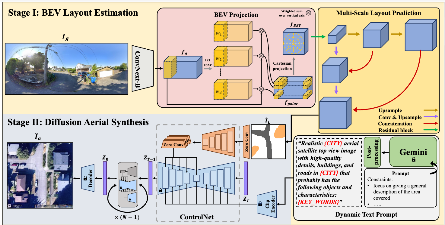
Aerial imagery analysis is critical for many research fields, but frequent high-quality aerial images can be costly to obtain. This work studies Ground-to-Aerial (G2A) synthesis to generate aerial images from easily collectible ground images, a challenging setting due to drastic viewpoint changes, occlusion, and limited visibility. We propose a Geometric Preserving G2A model (GPG2A) with two stages: (1) predicting a Bird’s Eye View (BEV) segmentation layout map from a ground image, and (2) synthesizing the aerial image from the predicted BEV layout and text descriptions. We also introduce VIGORv2, a new multimodal cross-view dataset with aerial images, maps, and text. Experiments show GPG2A produces more geometry-preserved aerial images than existing methods and benefits applications such as data augmentation for cross-view geo-localization and sketch-based region search.
Xiaohan Zhang, Xingyu Li, Waqas Sultani, Chen Chen, Safwan Wshah
IEEE Transactions on Pattern Analysis and Machine Intelligence (T-PAMI), 2024
Cross-area generalization on CVUSA, CVACT, and VIGOR
Read research summary and view figure
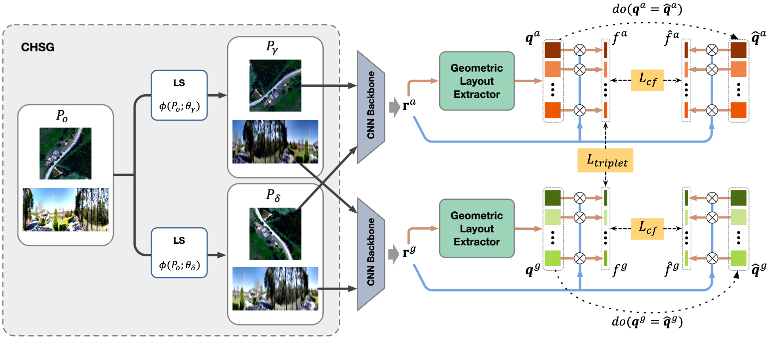
Cross-View Geo-Localization (CVGL) estimates the location of a ground image by matching it to geo-tagged aerial images. While recent methods perform strongly on standard benchmarks, they often degrade in cross-area evaluation (train/test from distinct areas), due to overfitting to low-level details and limited geometric layout modeling. Building on a Geometric Layout Extractor (GLE), we propose GeoDTR+ with an enhanced GLE that better captures correlations among visual features. We further introduce Contrastive Hard Samples Generation (CHSG) to strengthen training. Extensive experiments show GeoDTR+ achieves state-of-the-art cross-area results on CVUSA, CVACT, and VIGOR by large margins while keeping same-area performance comparable to prior SOTA, and we provide detailed analyses of the method.
Matias Mendieta, Boran Han, Xingjian Shi, Yi Zhu, Chen Chen, Mu Li
IEEE/CVF International Conference on Computer Vision (ICCV), 2023
Read research summary and view figure
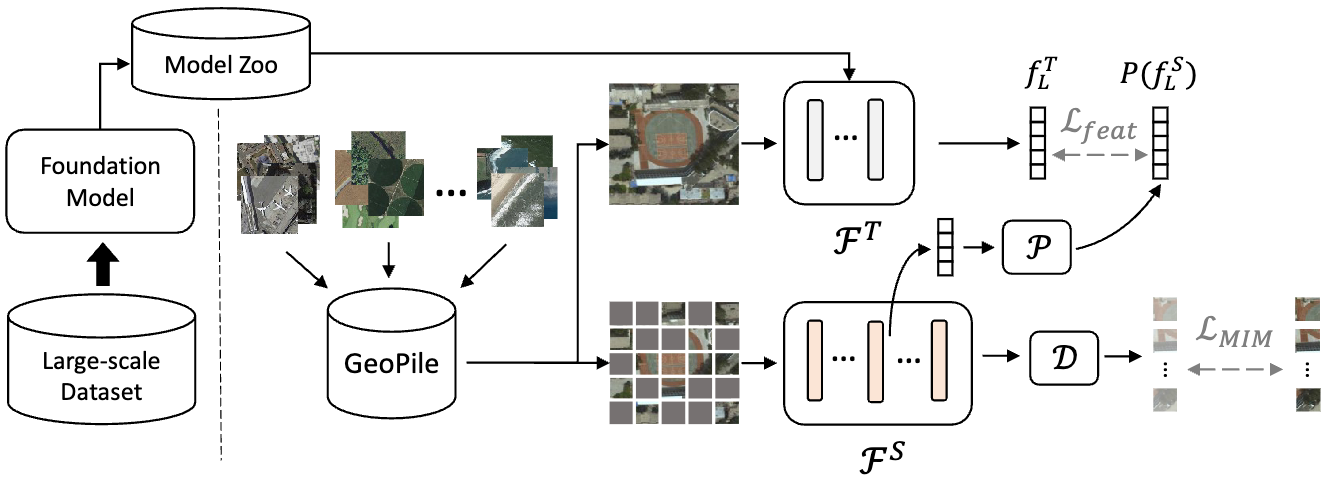
Geospatial technologies support important applications such as agriculture, urban planning, and disaster response, motivating foundation models for the domain. Existing approaches for geospatial pretraining can offer limited gains or incur prohibitive training costs. We propose a resource-efficient paradigm: (1) constructing GeoPile, a compact but diverse dataset to promote feature diversity, and (2) performing multi-objective continual pretraining from large ImageNet-22k models to retain strong generic representations while learning in-domain features. The resulting geospatial foundation models outperform prior geospatial pretraining methods across seven downstream datasets spanning change detection, classification, multi-label classification, semantic segmentation, and super-resolution, with reduced resource and carbon impact.
Sijie Zhu, Linjie Yang, Chen Chen, Mubarak Shah, Xiaohui Shen, Heng Wang
IEEE Conference on Computer Vision and Pattern Recognition (CVPR), 2023
Unified retrieval + reranking • Efficient large-scale VPR
Read research summary and view figure
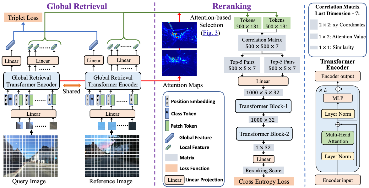
Visual Place Recognition (VPR) localizes a query by matching it to a reference database. Traditional pipelines use CNN global retrieval followed by RANSAC-based geometric verification for reranking, but RANSAC ignores other useful cues such as local feature correlations and attention. We propose R2Former, a unified transformer framework that performs both retrieval and reranking end-to-end. The reranking module leverages feature correlation, attention values, and xy coordinates to determine if an image pair is from the same location, and can also be used as a plug-in for other backbones. R2Former significantly outperforms prior methods on major VPR datasets while using less inference time and memory, and achieves state-of-the-art performance on the hold-out MSLS challenge set.
Sijie Zhu, Taojiannan Yang, Chen Chen
IEEE Conference on Computer Vision and Pattern Recognition (CVPR), 2021
Benchmark + realistic setting beyond aligned pairs
Read research summary and view figure
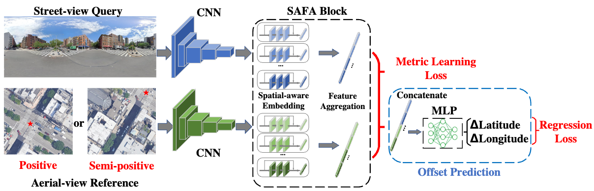
Cross-view geo-localization matches street-view queries to GPS-tagged aerial images. Prior datasets often assume a perfectly aligned one-to-one correspondence between each query and a centered reference image, which is unrealistic in practice. We redefine the problem under a more realistic assumption: queries can be arbitrary within an area of interest, and reference images are captured before queries emerge. This breaks one-to-one retrieval and allows multiple references to cover a query location. We introduce VIGOR, a large-scale benchmark for this setting, along with an end-to-end coarse-to-fine localization framework. Beyond retrieval accuracy, we also evaluate localization error in meters using raw GPS. Results show the realistic setting remains challenging and motivates further research.
Yu Shen, Sijie Zhu, Taojiannan Yang, Chen Chen, Delu Pan, Jianyu Chen, Liang Xiao, Qian Du
IEEE Transactions on Geoscience and Remote Sensing, 2021
Read research summary and view figure
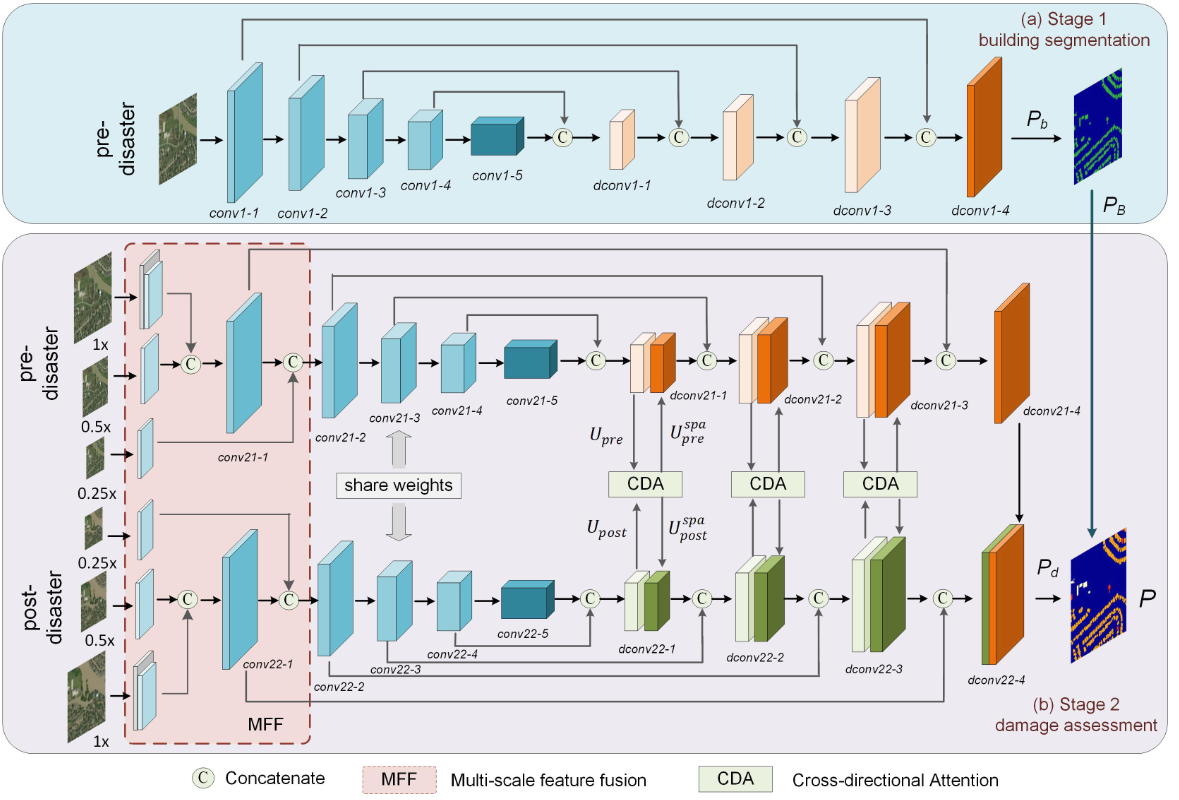
Building damage assessment from satellite imagery supports fast disaster response by predicting damage extent using paired pre- and post-disaster images. Many methods concatenate the image pair without explicitly modeling their correlations. We propose BDANet, a two-stage CNN: a first-stage U-Net detects building locations, and its weights are shared with a second stage for damage assessment. The second stage uses a two-branch multiscale U-Net backbone where pre- and post-disaster images are processed separately, and a cross-directional attention module captures their correlations. We also apply CutMix augmentation to address difficult classes. BDANet achieves state-of-the-art performance on the large-scale xBD dataset.
Yu Shen, Sijie Zhu, Chen Chen, Qian Du, Liang Xiao, Jianyu Chen, Delu Pan
IEEE Transactions on Geoscience and Remote Sensing, 2020
Read research summary and view figure
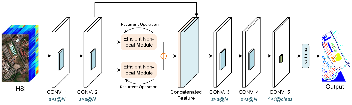
Hyperspectral image (HSI) classification benefits from spectral-spatial features, but each pixel can depend on both nearby and far-away pixels, requiring long-range context. We propose ENL-FCN, a deep fully convolutional network with an efficient nonlocal module to capture long-range contextual information. Unlike standard nonlocal networks, the module aggregates context along a criss-cross path for computational efficiency and can be applied recurrently so each pixel integrates information from all pixels. ENL-FCN is plug-and-play, parameter-efficient, and reduces computational cost while achieving state-of-the-art performance on multiple HSI benchmarks.
Changlin Li, Taojiannan Yang, Sijie Zhu, Chen Chen, Shanyue Guan
IEEE Conference on Computer Vision and Pattern Recognition (CVPR) (EarthVision Workshop), 2020
Read research summary and view figure
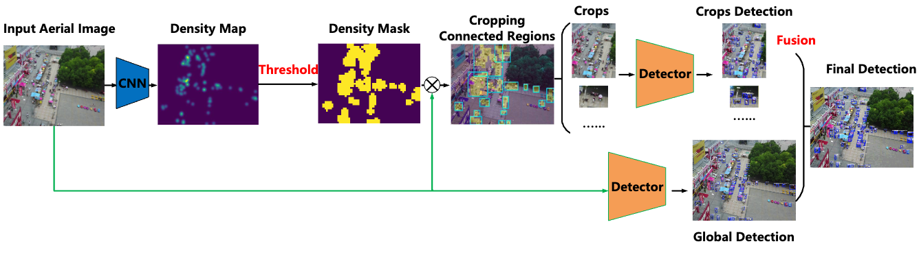
Object detection in high-resolution aerial images is challenging due to large object scale variation and non-uniform object distribution. A common approach is to split images into uniform crops, but this may waste computation on empty regions or miss optimal crop placement. We propose DMNet, a density-map guided object detection network that uses an object density map to statistically guide cropping. DMNet includes a density map generation module, an image cropping module, and an object detector; it learns scale information from density intensities to form cropping regions. Experiments show DMNet achieves state-of-the-art performance on aerial datasets such as VisionDrone and UAVDT.